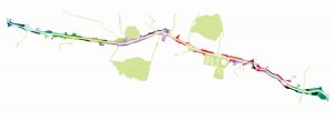
Rio Medellin Botanical Park
First place winner in the II latinamerican bienal of landscape architecture. Currently in building process.
This is a project of public space and landscape recovery that includes the most important hydric system of the city, and also aims to create an integrated territory with its inhabitants and natural systems.
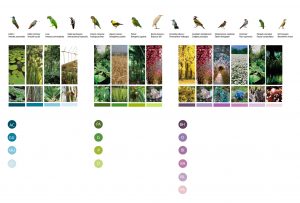
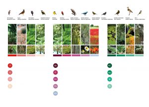
Autochthonous regional species of the river’s biotic passageway.
Scheme: Latitud Taller de ciudad y arquitectura
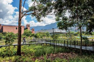
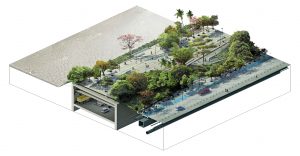
Pathways in the woods and understorey.Render: Latitud Taller de ciudad y arquitectura
ENVIRONMENTAL SYSTEM OF CONECTIVITY FOR THE CITY: LANDSCAPE INTENTIONS
The Project proposes to potentiate the ecological system of the city that lives in the river’s biotic passageway, achieving this by implementing associations of native species on these new public spaces, therefore enriching the city’s flora and fauna.
Nature, therefore, becomes part of the existing and proposed roadway infrastructure, creating a botanical park that arranges the city’s natural systems, organizing them in an environmental circuit within Aburra Valley.
The park seeks to develop environmental awareness, to preserve autochthonous regional species and to connect the valley’s biotic web protecting it from fast urban growth, as well as to appreciate the diverse flora in the territory and to educate through public space.
The proposal focuses its efforts on the implementation of new biotic processes that with the passing of time should reconstruct the river’s environmental axis.
This implies that the design was not conceived as a finished product but as the beginning of diverse processes that will evolve through time; seeking one goal: creating an ecosystem with biodiversity that is self-sustaining and able to regenerate the existing environmental tissue. The design seeks a space that evokes nature in an urban context.
 LANDSCAPE RECOVERY STRATEGIES
-
- To potentiate the river as an active and dynamic biotic passageway.
-
- To implement a vegetation that is based on species associations, rather than prioritizing the individuals for functional and ornamental uses. The aim of this is to augment the exchange capacity and the transformation through time by boosting the growth of groups of plants that could generate biodiversity.
-
- To create “succession models” for the vegetal species through time, to generate a greater cohesion between the proposed associations so that a more complex ecosystem could develop through new processes in time.
- To introduce a diversity of botanical situations (reserve areas, introduced landscape units, riverbank’s biotic passageway, green areas for pedestrians, etc.)
Isometric of the tunneling.
Render: Latitud Taller de
ciudad y arquitectura
SPECIES SELECTION CRITERIA ACCORDING TO THE SOIL FOR PLANTATION
-
- Riberbank: naturally inclined ground above the border of the river, with unstable characteristics, over which vegetal associations can be planted to retrieve the biotic passageway and the alluvial plain.
-
- Tunneling: soil over the tunneling structure which limits the planting area to a depth of 1.5 m, in consequence, conditioning the size, weight, and shape of the vegetal individuals that are planted in these areas.
-
- Natural ground: an ideal area for planting large species that generate big shadow areas, it has lesser restrictions and more opportunity for experimentation in both forest and coverage models of association, always trying to create unique environments in the park.
- Service routes: natural ground that is associated with roadways, pedestrian crossways, bicycle lanes and some subterranean networks, which restricts the species selection criteria to certain codes and laws about pedestrian and vehicular mobility; also includes the presence of structures that could be affected by the vegetal growing process.
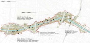
Plan: Latitud Taller de ciudad y arquitectura